Aerial Imaging

Aerial Imaging
Drone Imaging: Revolutionizing Agricultural Monitoring and Management
In the ever-evolving landscape of agriculture, staying ahead requires innovative solutions that offer insights and efficiencies.
One such groundbreaking technology making waves in the industry is Falcon’s drone imaging services. By harnessing the power of unmanned aerial vehicles (UAVs) equipped with advanced imaging systems, farmers are gaining unprecedented access to real-time data about their fields, crops, and environmental conditions, leading to more informed decision-making and improved agricultural practices.
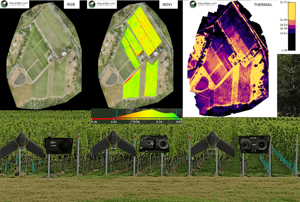

How Drone Imaging Works
Falcon’s Drone imaging services involves the use of UAVs equipped with high-resolution cameras, multispectral sensors, and other imaging technologies to capture detailed aerial imagery of agricultural landscapes.
These drones are programmed to fly predetermined flight paths over fields, capturing data at various wavelengths and resolutions. The collected imagery is then processed using specialized software to generate actionable insights and visualizations that enable farmers to assess crop health, detect anomalies, and make informed management decisions.
Benefits of Drone Imaging
- Crop Monitoring and Health Assessment: Falcon Drone imaging qualified and insured pilots provide farmers with a bird's-eye view of their crops, allowing them to monitor plant health, growth patterns, and stress indicators with unparalleled precision. By detecting early signs of pest infestations, nutrient deficiencies, or disease outbreaks, farmers can take timely corrective actions to mitigate risks and optimize yields.
- Precision Agriculture: With Falcon’s drone imaging services, farmers can implement precision agriculture techniques by tailoring inputs and management practices to the specific needs of individual crops or field zones. By analyzing multispectral imagery and generating detailed maps of vegetation indices, soil moisture levels, and crop variability, farmers can optimize resource allocation, minimize waste, and maximize productivity.
- Environmental Monitoring and Conservation: Falcon’s Drone imaging services enables farmers to assess environmental conditions and monitor changes in land use, vegetation cover, and water resources over time. By identifying areas prone to erosion, nutrient runoff, or habitat loss, farmers can implement targeted conservation measures to minimize environmental impact and promote sustainable land management practices.
- Efficient Field Scouting: Traditional methods of field scouting can be time-consuming and labor-intensive, often yielding limited insights due to the constraints of ground-level observation. Falcon’s Drone imaging service streamlines the scouting process by providing farmers with comprehensive aerial views of their fields, allowing them to quickly identify areas of concern and prioritize inspection efforts more effectively.
- Data-Driven Decision-Making: By integrating Falcon’s drone imaging data with other sources of agronomic information, such as weather forecasts, soil sampling data, and historical yield records, farmers can make data-driven decisions that optimize productivity, minimize risk, and improve overall farm profitability. Whether adjusting irrigation schedules, fine-tuning fertilizer applications, or planning crop rotations, drone imaging empowers farmers to make informed choices that drive success.
Future Outlook
As drone technology continues to evolve and become more accessible, the potential applications of drone imaging in agriculture are limitless. From automated crop scouting and weed detection to predictive analytics and autonomous decision-making, drones are poised to play a transformative role in shaping the future of farming.
In conclusion, Falcon’s drone imaging service represents a game-changing innovation in agriculture, offering farmers a powerful tool for monitoring, managing, and optimizing their operations with unprecedented precision and efficiency. By embracing this technology, farmers can unlock new insights, increase resilience, and sustainably meet the challenges of feeding a growing global population while preserving the health of our planet’s ecosystems.


