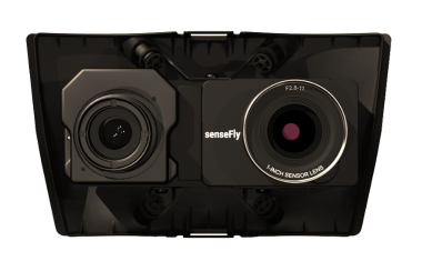
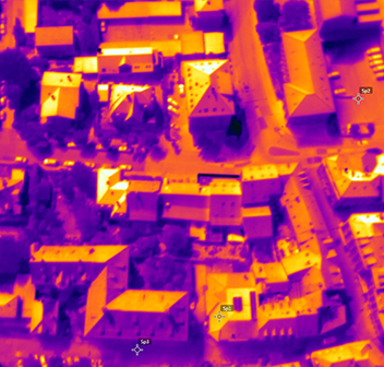
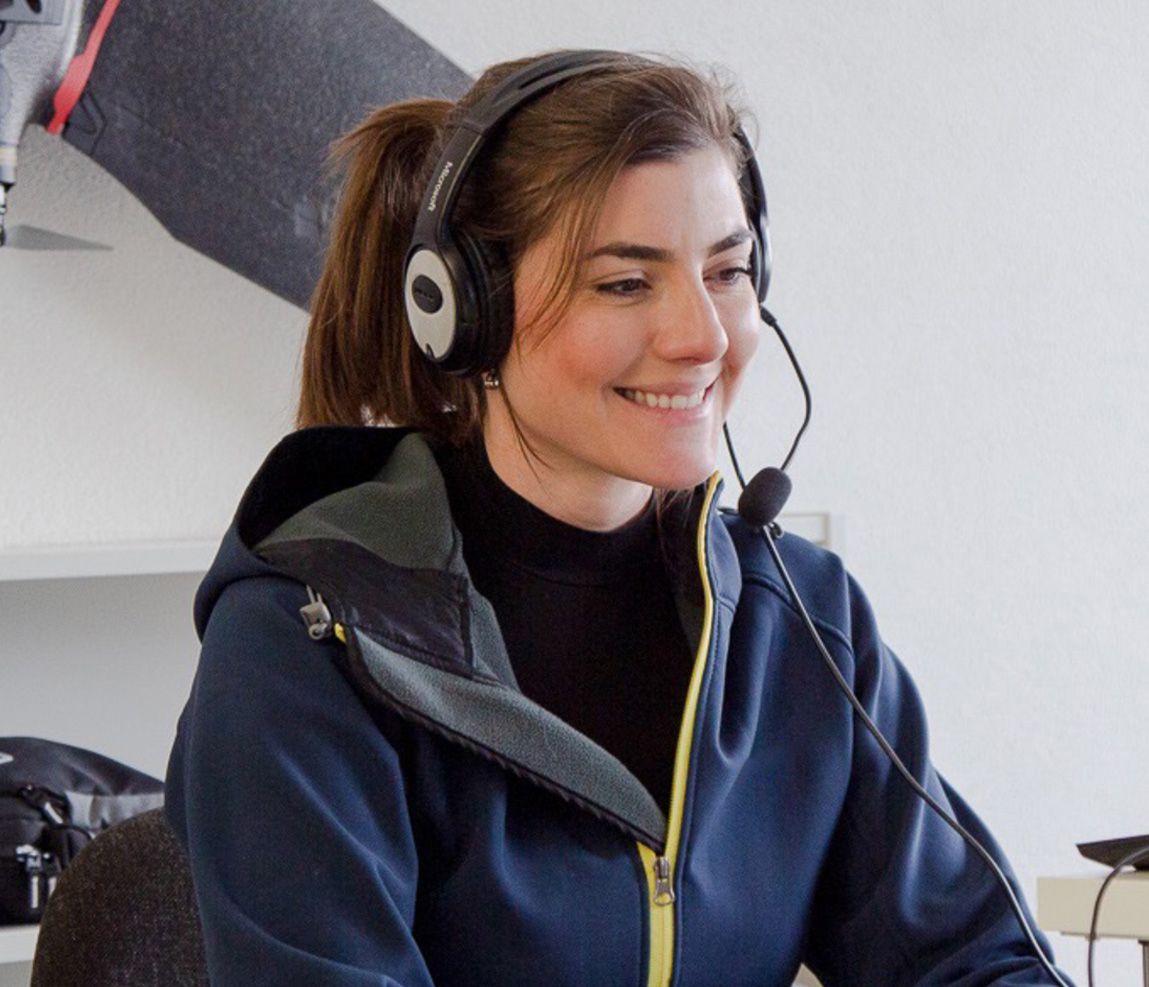
Blue UAS registered

Public safety drone

Carried in a backpack, operated by one person, and deployed in 3 minutes, eBee TAC Public Safety is a photogrammetry drone that provides 2D, 3D and thermal aerial data over large areas.

Specially designed for public safety

Features

First responders mapping solution

Validated cyber-secure

90 minutes flight time

Efficiently map up to 500 ha / 1,235 ac while flying at 120 m / 400 ft.
With a flight time of 90 minutes and a flight range of 55 km / 34 mi, eBee TAC Public Safety can cover large and inaccessible areas.

Takeoff weight 1.6 kg / 3.5 lbs

Thanks to its lightweight, eBee TAC Public Safety, can be safely operated under many regulatory frameworks. Moreover, it has the best ratio energy/MTOW compared to heavier VTOL drones, offering better energy efficiency.

3D, RGB, multispectral and thermal cameras

eBee TAC Public Safety is compatible with a wide range of interchangeable photogrammetry cameras that capture reliable aerial imagery – from 3D models to orthomosaics – to suit every mapping job.

1.5 cm / 0.6 in accuracy

With the RTK / PPK optional software, the public safety drone achieves an absolute accuracy down to 1.5 cm / 0.6 in, without ground control points (GCPs).

Remote ID, C2 and C6

We have anticipated upcoming drone regulatory frameworks in the U.S. and Europe by having the eBee TAC Public Safety ready with Remote ID identification system approved by the FAA.

Why eBee TAC Public Safety

Fully operational solution

North America

U.S. OOP approved
eBee drones are the only approved UAVs to fly Operations Over People (OOP) in the U.S.
Canada OOP approved
Approved to run Operations Over People (OOP) in Canada.

Europe

C2 certified
Operators free to fly 30 meters from uninvolved people.
BVLOS & OOP simplified
C6 certified for BVLOS Standard Scenarios and simplified SORA approval process thanks to M2 Ground Risk Mitigation.

Remote ID

Approved by the FAA
eBee TAC Public Safety has Remote ID identification system approved by the Federal Aviation Administration (FAA) of the United States.

Safety tests

Safety impact tests performed to demonstrate operational safety around people
Free from hard front plastic parts and no front-facing motor
Flight planning software integrates fail-safe protocols
Live air traffic awareness with Ping USB accessory

Blue UAS registered by U.S. DoD

eBee TAC Government and Public Safety are the first fixed-wing approved drones to be added to the Blue UAS Cleared List by the Defense Innovation Unit (DIU) for procurement by the U.S. Department of Defense (DoD) and government agencies without an DoD exception to operate. 

Easy to use

Operated by one person

Easy to use, easy to train. eBee TAC Public Safety can be operated by one person.

Rugged transport case

Easily transported in a rugged transport case suitable for many weather conditions.

Easy maintenance

Maintained without requiring external support.

3 minutes deployment

Standalone and PPK deployment, 3 minutes. With RTK, 10 minutes.

eMotion

Flight management software

Easy to use, with advanced features. All the functionality you need to collect and manage geospatial data to act with precision.

3D flight planning

Plan, simulate and control advanced missions in any terrain, including mountainous areas.

Mission ready

Select the area you want to map, and the software generates the optimized flight plan. Automated flight and landing.

Live flight plan change

Easily hold the drone in position, adjust the flight path and/or the landing spot during flight.

Multi-drone operations

Fly up to 4 drones at the same time, all controlled from 1 ground control station.

Offline planning

Fly in disconnected environments thanks to offline background maps and elevation data.

Optimized modes

Horizontal, corridor, point of interest (POI), multiple or fully custom mission blocks.

“Being able to adjust or change the flight plan with eMotion during the flight is one of the most valuable features to us. For example, we recently had to do a mission with our eBee TAC near an aid and rescue helicopter that had 7 minutes to take off in case of an emergency. With eMotion, we were able to clear the helicopter flight area in a couple of minutes, avoiding any potential risk.”
– Major French Armed Forces –

Proven reliability

eBee TAC is purpose-built for the mapping demands of public safety applications to improve mission effectiveness in a variety of terrains.
The U.S. Federal Aviation Administration (FAA) drone registration data confirms that the eBee is the most used fixed-wing drone in the United States.

12 Yearts

Industry experience

90,940 +

Flight hours

173,600 +

Cumulated flights

1/1,750 hours

Fly away probability

Less time on site

eBee X drone
500 ha / 1,235 ac*
2.9 cm / 1.14 in per pixel
* with senseFly S.O.D.A. 3D nadir imagery
Quadcopter drone
Up to 40 ha / 99 ac
3.6 cm / 1.41 in per pixel
Terrestrial tools
8 ha / 9 dc

Rugged and durable solution

Drone underbody skin made of durable Curv® Polypropylene thermoplastic composite. A shock-absorbent construction that endures continuous linear landings without damaging the drone, even in harsh terrain.
eBee TAC Public Safety has a modular design that allows easy maintenance and fast repairs in the field.

NDAA compliant

eBee TAC is compliant to the National Defense Authorization Act (NDAA) of the U.S. federal law, an essential requirement to prevent maliciously hacking.
The drone components, hardware and software, are not from any of the blacklisted companies or countries, and the connectable solution has been proven cyber-secure.

Post-processing compatibility

Once the data is collected by the drone, the images are post-processed with a wide range of compatible software to generate the 2D and 3D maps.

What our users say

eBee TAC Public Safety reviews

“It is the only collection platform organic to SFABs and has proven a critical enabler for tactical advise and assist efforts.”

Us Army

SFAB, United States

“We have a quadcopter, but it doesn’t fit our requirements. We need much more coverage to map large areas, and we get that with the eBee TAC and the S.O.D.A. 3D camera. So for us, eBee has no competition. It is the only drone that allows us to do our work and get the outputs we need.”

French land army

“There’s been a gap in situational awareness knowledge in the defense and disaster relief sectors for many years now. Other UAVs, like small planes or satellites, cannot capture as many details as a drone, which puts operators at a disadvantage in the field.”

Jarrett Heavenston

Co-founder/CEO at Tough Stump Technologies

Hardware and software included

What you'll get

IP67 military transport case

Encrypted SD Cards

Flight management software

Lithium-polymer endurance batteries

Fly up to 90 minutes per flight

Smart battery charger and discharger

Spare propellers and pitot kit

USB ground modem

Interchangeable sensors

Drone cameras available for eBee TAC Public Safety

Collect data for decision-making. Outputs include detailed 3D models, thermal maps, terrain and surface models, and high-resolution orthomosaics.

S.O.D.A. 3D

3D mapping. Patented photogrammetry sensor that changes orientation during flight. Its tilting technology provides excellent results in vertically-focused environments.

Aeria X

2D mapping. Optimize exposure time under numerous light conditions – including low-light – with this 24 megapixel drone photogrammetry camera for RGB outputs.

Duet T

Thermal mapping. Dual RGB and FLIR thermal camera, suitable for night flights. The Duet T is a radiometric camera.

S.O.D.A.

Capture sharp aerial images and translate them into detailed orthomosaic maps with this robust and efficient photogrammetry camera.

Corridor

With its portrait camera position, Corridor sensor requires 30% fewer images to map the same linear route. This, in turn, means 30% shorter processing times.

Duet M

Capture geo-accurate multispectral maps and digital surface models quickly and easily with this RGB and multispectral camera.

S.O.D.A. 3D

3D map

Aeria X

2D orthomosaic map

Duet T

Thermal map

Drone backpack

Durable drone protection and portability. Laptop pocket and rain cover. 4.6 kg / 10 lbs empty, 10 kg / 22 lbs loaded.

Ping USB

Increase your airspace awareness by viewing live air traffic data directly within eMotion.

GeoBase by Septentrio Altrus NR3

Enable high-accuracy workflow with this plug-and-play GNSS.

Remote control

Operate your eBee TAC drone manually.

Radio tracker

Safeguard against unexpected aircraft signal loss while flying in high winds, mountainous areas or very large areas out of the line of sight.

Spare and maintenance kits

Wings, pitot tube, vertical surfaces and propellers.

RTK / PPK

Achieve absolute accuracy of down to 1.5 cm / 0.6 in with available RTK / PPK.

Immediate support

Should you require support for your mission or when coming back from the field, our global support network and R&D team stand by to help. We are recognized throughout the industry for excellence in customer service. Our drone solutions include lifetime hardware, payload and eMotion support, plus free software and firmware updates.
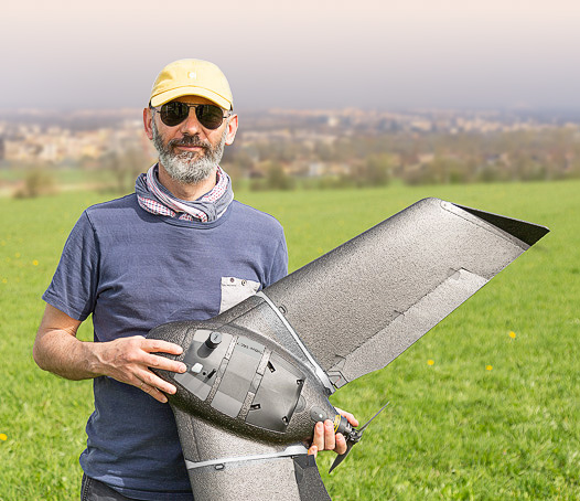
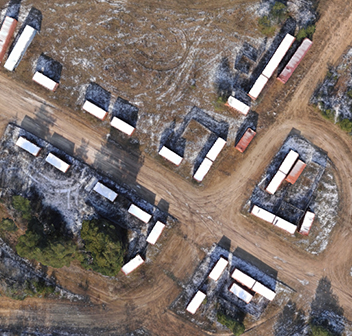
Dedicated training

eBee TAC addresses public safety needs, and so does this training available online and in-person. With a civil and military background, our training team has performed real missions worldwide. In addition, we offer customized training focused on different field missions at our headquarters in the U.S. and Europe.

Shopping Cart